Category Archives: rambles

celebrating summer–medieval-style

Ah summer, the season when the meadow blooms and the stag farts! Here are some sprightly words celebrating the season we’ve just begun. They’re the lyrics to a bouncy little ditty circa the year 1260 that most students going through music history courses will have have run across. If your Middle English is about as bad as mine, I’ve provided a translation.

Sumer is icumen in,
Lhude sing cuccu!
Groweþ sed and bloweþ med
And springþ þe wde nu,
Sing cuccu!
Awe bleteþ after lomb,
Lhouþ after calue cu.
Bulluc sterteþ, bucke uerteþ,
Murie sing cuccu!
Cuccu, cuccu, wel singes þu cuccu;
Ne swik þu nauer nu.
Pes:

Sing cuccu nu. Sing cuccu.
Sing cuccu. Sing cuccu nu!

Summer has come in,
Loudly sing, Cuckoo!
The seed grows and the meadow blooms
And the wood springs anew,
Sing, Cuckoo!
The ewe bleats after the lamb
The cow lows after the calf.
The bullock stirs, the stag farts,
Merrily sing, Cuckoo!
Cuckoo, cuckoo, well you sing, cuckoo;
Don’t you ever stop now,
Sing cuckoo now. Sing, Cuckoo.
Sing Cuckoo. Sing cuckoo now!

You can sing it all by yourself, but it’s designed to be four-part round that you sing over a two-part ground. If you’re tired of “Row, row, row your boat” as the only round to sing at summer camp this might be just the ticket. Below is the music (click it to enlarge). And if you want to sing along, click here for an mp3 file [ source ].

notation to sumer is icumen in

Sumer is icumen in, transcribed from the ca. 1260 manuscript by Blahedo, used under a Creative Commons Attribution Share Alike 2.5 license [ source ].

Warning: Once you listen to it a few times–and maybe even sing along–it gets to be one of those “It’s a Small World” earworm tunes that you’ll have a hard time getting rid of.

Find out more.
And if anyone’s reading this in the Southern hemisphere, here’s Ezra Pound’s winter parody. (I guess he wasn’t particularly fond of winter.)

"eucalyptus autumn"

The Japanese language has many poetic names for the seasons. One phrase that I’ve found particularly beautiful is take no aki, or “bamboo autumn.” It refers to the period in middle- to late-spring when leaves of some bamboos turn yellow and fall from the plants. In addition to the gorgeous built-in poetic analogy, I like how the phrase grounds a specific portion of the season by invoking a natural process that presumably would have been understood by a good portion of the population.

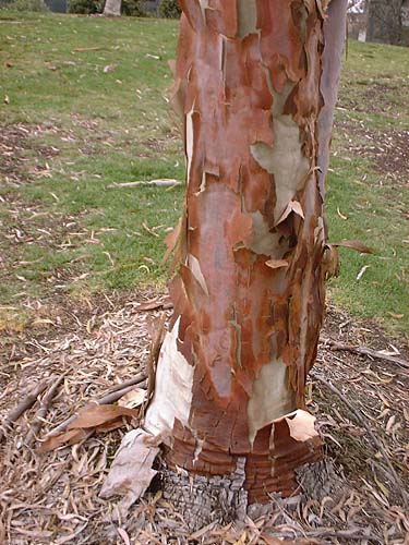
Another eucalyptus with exfoliating bark When I take my lunch break during the week and head to the gym, I follow a path that takes me by a small cluster of eucalyptus trees planted in a patch of lawn. Several of the trees have beautifully smooth trunks which are covered with a delicately mottled silvery bark. Once a year, usually late in spring or early in summer, the bark exfoliates, dropping off in small chunks that reveal the surprise: a bumpy, pale ocher layer of new bark underneath.


Exfoliating eucalyptus Another of the trees drops larger, thin, brittle sheets of red-brown bark, revealing a deliciously pale icy green below.

Many eucalyptus species have bark that exfoliates, as do many other trees, such as the sycamores that congregate in the moister areas of the local canyon bottoms. So…why shouldn’t we have a name for when that happens? Why shouldn’t we come up with ways to reattach language to natural processes and the world around us? Why not refer to this awkward transitional spring-summer period we’re in as “eucalyptus autumn?”


(Okay, okay, if you must quibble, not all of the 740-plus eucalyptus species shed their bark. And those that do, don’t do it at exactly the same time. But I vote for anything that grounds us more securely in the cycles of the world. And language, being such a fundamental component of our existence, seems like a great tool to use to accomplish the goal.)

virtual vacations: then

In talking about visiting places virtually it’s easy to get caught up in our totally cool advanced state of technology and forget that this sort of visit-by-proxy has been going on for ages.

Homer’s Odyssey gave listeners accounts–albeit mythical–of distant worlds and peoples. In The Persian Wars Herodotus gave readers a more accurate travelogue of places they would very likely never encounter on their own.

The visual arts have always played a strong informational function in this way. Topographically-motivated paintings–works done with varying degrees of verisimilitude–go back to the early days of representation, and gained a high level of polish by the time of the Dutch landscapists such as Albert Cuyp, Salomon van Ruysdael and Jan van Goyen. Paintings by Canaletto, in addition to being snazzy souvenirs for wealthy travelers on the Grand Tour, gave viewers perspectively accurate renditions of an exotic Italy. And the list goes on…

Canaletto. Venice – Grand Canal
Looking South-West from the Chiesa degli Scalzi to the Fondamenta della Croce, with San Simeone Piccolo.
c. 1738.
Oil on canvas – National Gallery, London, UK.
[ source ]


When photography came along its main-line link to reality and reputation for truthfulness kicked up the perceived value of its artifacts as ways to know the world. When the photographic stereoview took the already hyper-real photograph and rammed it into three dimensions people found it revelatory. Millions of stereoviews flooded the market, and you could take virtual vacations to most of the known world: Egypt, South America, Europe, the American West–all over.

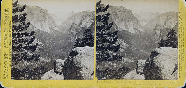
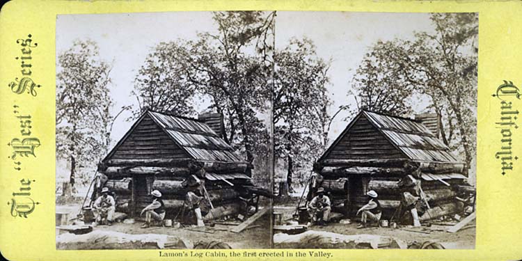
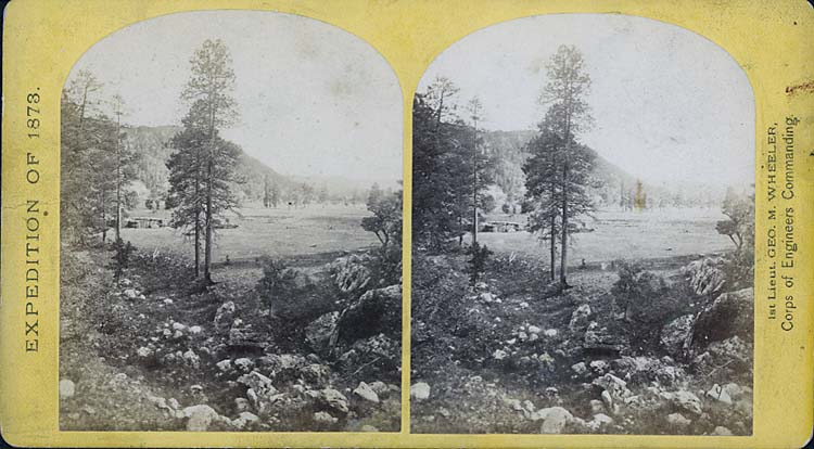
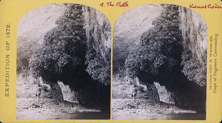
Here are a few of my handful of 1870s eBay stereoviews of places in the west I’m particularly interested in. If you’ve never practiced “free viewing”–basically letting your eyes relax to the point where the left eye focuses on the left image and the right on the right one–give it a try with these. The process might be easier if you click on the image to enlarge it. You know that you’re on the right track when you start to see three images, the left one on the left, the right one on the right, and the stereo composite in between.

(Remember the “Magic Eye” pictures from the 1990s? Those posters of seemingly random piles of pixels where some sort of cheesy 3D image would suddenly come to life when you got your eyes to relax just so? If you could make those pop, you’ve got the idea behind stereo free-viewing down.)

This first is a basic Carleton Watkins view of Yosemite Valley:

Watkins Yosemite Valley stereoview


And this is a shot of Lamon’s cabin, the “first” structure built in Yosemite Valley. (I doubt the Native Americans inhabiting the Valley lived alfresco year round, however…)Lamon's cabin, Yosemite Valley


A Southwestern montane forest photographed by Timothy H. O’Sullivan during the 1873 Wheeler expedition, one of the great Western surveys:O'Sullivan meadow stereoview


And finally a shot of Kanab Canyon taken by William Bell during the 1872 Wheeler expedition. But wait! What the hell is in this picture? In the finest tradition of using Google Maps to find accidentally recorded images of naked people, could this be? A naked man?Naked guy in Kanab Canyon stereoview


Yeah, tourism and voyeurism, hand in hand, even back then…

niagaras of the east and west

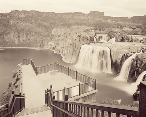
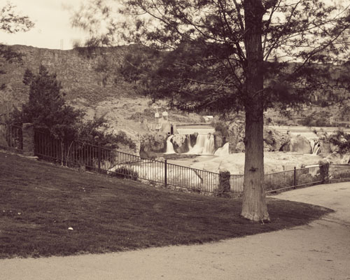
Earlier I posted a couple of my tourist pictures of Idaho’s Shoshone Falls, the “Niagara of the West.” I’ve just begun to scan and print the negatives of the large-format work from the trip. Here are three from the falls:

Viewpoint at Shoshone Falls, Snake River, Idaho:Viewpoint, Shoshone Falls, Idaho

Shoshone Falls Park:Shoshone Falls Park, Snake RIver, Idaho

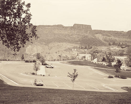
Parking Lot at Shoshone Falls Park:Parking Lot, Shoshone Falls Park, Idaho

Interestingly, in the pile of newspapers John had saved for me from while I was away, was a book review in the L.A. Times of Ginger Strand’s Inventing Niagara. Interestingly too, in browsing for the book on the web I noticed that it has two different subtitles: “Beauty, Power and Lies,” as well as the more provocative “How Industry, Commerce and Art Conspire to Sell (Out) a Natural Wonder.”

I’d lamented that the Niagara of the West had been despoiled and exploited to an unseemly theme-parkness, and in this long quote in the review Strand has similar things to say about the Niagara of the East:

Manicured, repaired, landscaped and artificailly lit, dangerous overhangs dynamited off and water flow managed to suit the tourist schedule, the Falls are more a monument to man’s meddling than to nature’s strength. In fact, they are a study in self-delusion: we visit them to encounter something real, then observe them through fake Indian tales, audio tours and IMAX films… We hold them up as an example of unconquerable nature even as we applaud the daredevil’s and power-brokers who conquer them. And we congratulate ourselves for preserving nature’s beauty in an ecosystem that, beneath its shimmering emerald surface, reflects our own ugly ability to destroy. On every level, Niagara Falls is a monument to the ways America falsifies its relationship to nature, reshaping its contours, redirecting its force, claiming to submit to its will while imposing our own on it.

Reviewer Tim Rutter, as much as he likes a lot of what Strand has to say, ends up finding the writing of the book to be tiring and frustrating. In that most post-modern technique now turning into cliche, the author’s process of writing the book plays a starring role in the book. When well done it can still be interesting, but in this example Rutter didn’t think that it was. Take that pronouncement under advisement, but it still sounds like the book is a worthwhile read.

long shelf life for seeds

When I’d heard years ago that a lotus seed from China had germinated after laying low for 1300 years I was pretty amazed. That was from seed collected in 1982 when Shen and Miller at UCLA sprouted a number of seeds that were radiocarbon dated to be anywhere from 95 to 1288 years old, plus or minus a few years.

But when I heard the news making the rounds now that a two-millennium-old date palm seed from Masada had sprouted, I was definitely impressed.

Studies of the lotus plants grown from the old seeds showed that all were abnormal, a fact that the scientists attributed to radiation-induced mutations that occurred as a result of naturally-occurring radiation in the soil where they were found. The date palm–which has been dubbed the “Methusalah tree”– however, has been growing spunkily since it was sprouted in 2005, and is now five feet tall. If that palm doesn’t take the cake in the more-heirloom-than-thou plant contest, I don’t know what would!

more about golf: virtual and in pictures

In South Korea 200,000 golfers a day are discovering that they don’t need golf courses to play the game anymore. The New York Times site ran a video piece on how virtual-reality golf is taking the golf world by storm. Take a look:

Virtual golf image

It’s golf–more or less–but with no unnecessary water use, herbicides or pesticides!

Artist Skeet McAuley did an artist’s residency with the Museum of Contemporary Art, San Diego in 2000. During that time he did a photographic series on golf courses in this area. Conceptually one of the things he was interested in was the total fake-ness of courses in relation to nature. In fact the title of the exhibition that came out of the residency was “The Garden of Golf.”

Skeet McCauley golf image

Skeet McAuley. The Meadows Del Mar Golf Course 4th Fairway, San Diego, California, 2000, Fujichrome print, 32 X 88 in. [ source ]


The resulting works were large, conventionally beautiful landscapes shot on golf courses. “Nature” has been rendered green and friendly, pretty and harmless. The images point out the way golf courses insidiously homogenize the natural world into a pre-ordered set of expectations of what nature should look like. In this world, there’s no room for snakes or tigers, weeds or brown patches of earth.

In this fiction of nature, going to a golf course becomes a virtual experience of the real world. It’s merely an approximation. At some level you may think you’re interacting with nature, but it ends up being as faked an experience as the Korean golfers and their golf simulation facilities.

teed off

In wildness is the preservation of the world.
Thoreau

In a desert, golf is the utter ruin of the known universe.
Me

This is the week of the U.S. Open golf tournament here in San Diego. Something like 42,500 spectator tickets per day have been sold for three days of practice rounds and four of competition. It’s being described as having a string of Super Bowls hitting town, seven days in a row.

To mitigate the potentials for traffic headaches they’re running shuttles for the spectators from Qualcomm Stadium, where they last played the city’s last real Super Bowl, up to the Torrey Pines golf facility, located on the brink of a cliff four hundred feet above the broad sands of Black’s Beach, one of the most spectacular clothing-optional beaches remaining anywhere. And yes, in addition to being a spectacular location for a nude beach it’s also a stunning place to plant a golf course.

Torrey Pines golf course

The Torrey Pines golf course [ source ]

In addition to the shuttles, they’re asking employers surrounding the golf course to limit how many employees show up at work this week. Beyond that, some of the office buildings that border the golf course effectively have been ordered shut down. Rumor is that they don’t want non-paying working stiffs to get a free look at Tiger or Phil or Adam, and that there are security concerns.

To add to the chaos, add to everything that this is finals week at the University of California, located just across the street from the golf course. Oops.

All that rubs me the wrong way. While it might be appropriate to maintain golf courses in cool, wet places like Scotland, it seems somewhere between bizarre and socially irresponsible to dedicate thousands of acres to the game of golf in the desert that is Southern California.

Water is at the forefront of many a Californian’s thinking. Many of us plant our gardens with drought-tolerant plants to maximize our water usage, and we try to limit the size of our lawns.

The San Diego County desert town of Borrego Springs grew to some size as an agricultural area, then began to attract people who grew the town even further. With those people came golf courses and the kind of water use that goes with them. The numbers aren’t exact, but of the total water intake of the town, something like ten percent goes to households (including landscaping), while twenty percent goes to golf courses. The rest goes to the farmers who are complaining that their aquifer is being drained dry. The proportion of water use between residences and golf courses is similar in other desert areas like Palm Springs. So, in a desert, huge numbers of golf courses don’t make much sense.

In addition to the water issues, golf courses are profligate users of pesticides and herbicides. After all, who wants to play golf on a course with brown spots? The Beyond Pesticides site posted a piece establishing links between golf course chemical use and various cancers, and Golf Digest of all publications ran an article, “How Green is Golf,” in its recent May 2008 issue looking at the issue.

Their conclusion? “New courses in the desert will become rarer,” and “The residue of synthetic chemicals are found in high concentrations as far away as the Arctic,” and this quote from a participant at a symposium at Pebble Beach: “From what I know about Augusta National, it’s really a television studio and not a golf course.”

There are signs of encouragement. The weekend San Diego Union-Tribune had an article on how master-planned golf communities are on the wane here in town. Much of the reasoning is economic. There were days when you could build a course here for a million dollars a hole, but rising land values have made that impossible. Seems that the majority of the people who bought into a golf community valued the perceived open space, but only a minority of them ever played the game. It’s proven to be cheaper to set down some hiking trails and preserve the natural open space. In addition, with what is known now about the health hazards of living on a golf course, who’d want to pay extra for the privilege?

So this week I get to endure the U.S. Open along with much of San Diego. While I’m doing that, I keep flashing to this picture in my mind of a driving range that I saw on the outskirts of Borrego Springs, probably the most socially responsible golf facility that I’ve seen anywhere. (Next time I’m out there I’ll try to snap a photo of it.) What tells you it’s a driving range isn’t the sickly fake-green color of its grass. In fact, nobody waters it, and the range is the color of the surrounding desert.

Instead, what tips its hand as a driving range are the golf balls scattered over the facility: thousands of the little white things, glistening in the vibrating mirage-inducing midday atmosphere like bright desert rocks arrayed over the pale brown sands. Now that’s my vision of paradise!

on the road–part 1

I guess it’s comforting that the blog doesn’t have a mind of its own and just write itself while I’m away on vacation…

Well, I’m back from points north, including 8 days in Yellowstone. Here’s a quick look at the trip now that I’ve had a chance to organize some of my tourist pictures.

Day 1, less than an hour out of Vegas, and I’m off pavement already. I could have sworn the map showed this stretch of the road going through the Mormon Mountains as being paved, so encountering dirt so soon is a bit of a surprise.
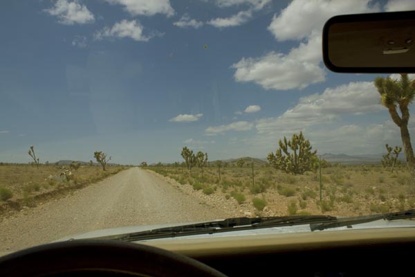
An hour out of Vegas

But as you can see it’s a good dirt road, as friendly towards Buicks and Honda sedans as it is towards my Jeep, and it connects up with an equally good gravel road as shown on the map. After a few dozen miles, the gravel road hooks up with pavement, as promised. But wait: Road Closed?

road closed

The blacktop looks fresh and smooth and the stripes shiny and new, so how closed can the road be? Besides there’s no way back other than the way I came, and the gas is getting low.


Well, yeah, half a dozen times the road disappears into the dry little river—generally not a good thing for a road to do—but fortunately they’ve built gravel alternate routes around the washouts for the half-dozen locals to use. So no need to backtrack.

One of a bunch of these lazy snakes taking a Club Med riverside siesta on the warm asphalt:Lazy snake
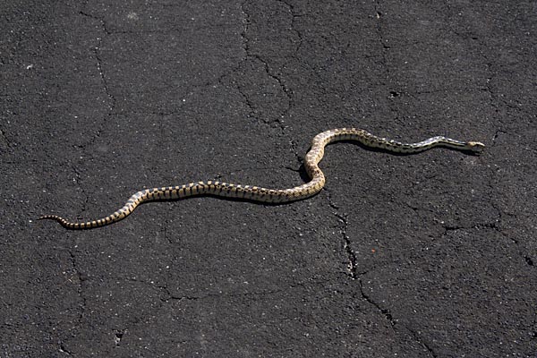
Along the Great Basin Highway

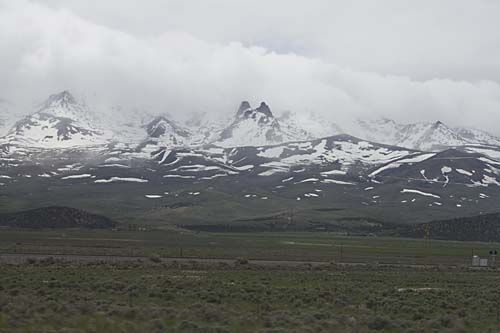
And finally the road hooks up with the Great Basin Highway, the eastern-most north-south route in Nevada. With snow-covered mountains on either side of the highway, it’s incredibly scenic. I’ve always loved California’s Highway 395 along the eastern escarpment of the Sierra Nevada, but I might now have a new favorite drive.

So, after 12 hours of driving from San Diego I’m at the first night’s destination, Great Basin National Park, on the slopes of Wheeler Peak, at 13 thousand and change in altitude the tallest in Nevada. The campground is almost 8,000 feet up, and pretty cold for the middle of May. And what’s this? Snow? Pretty exotic for someone from San Diego.

Day 2 begins with a drive up to the end of the road on Wheeler Peak, to over 10,000 feet elevation, and there the snow picks up. Then back down 3,000 feet to the peak’s caves, Lehmann Caves and year-round 50-degree comfort.
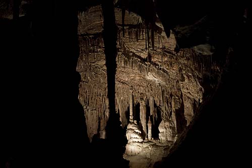
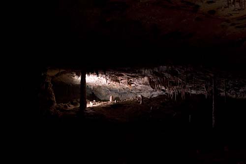
Lehmann Caves

Lehmann Cave

The caves are a medium-sized complex in not-pristine condition. In the early days of the caves, paying your entrance fee entitled you to break off a stalactite or two to take home. And there’s a spot where people used soot from their candles to record their initials on the roof of the cave—tacky and interestingly historical at the same time.
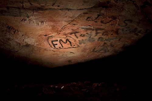
Graffiti in Lehman Caves

More travel on the Great Basin Highway gets me to my first real photographic destination, Shoshone Falls, which was documented by expeditionary photographer Timothy H. O’Sullivan in 1868 and 1874. For something that has been called the “Niagara of the West,” the falls were surprisingly difficult to find. They appear nowhere on the Triple-A Idaho state map, and if it weren’t for there being a street named Falls Boulevard in Twin Falls, I might not have found them. Yes, there was a sign. Partially obscured behind a tree.

O’Sullivan’s images of the falls are clear, forceful, direct depictions of a force of nature. You can feel the awe he felt as he stood on the brink.

Timothy H. O’Sullivan. Shoshone Falls, Snake River, Idaho, View Across the Top of the Falls, 1874. [ source ]


Today, what you find is a major water feature domesticated through hydroelectric impounds, and its banks have houses on one side and a bland suburban looking Frisbee and picnicking park on the other. It was like seeing a wild lion dressed up in a pink tutu and forced to walk on its hind legs. But it’s the sort of destination where the human/nature edges and collisions are dramatic, so out comes my more serious camera gear.
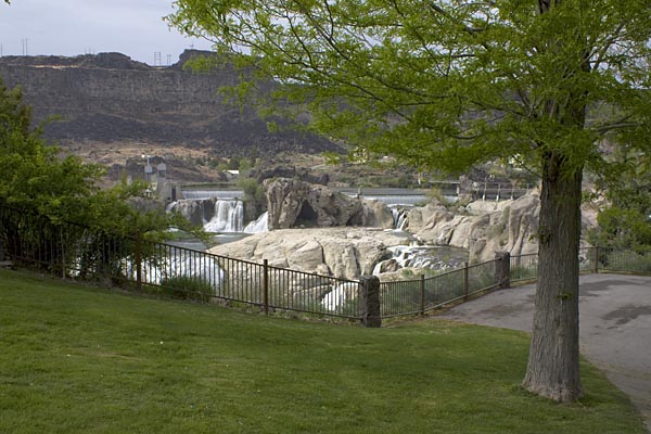

Next: On to Valley of the Moon, and Yellowstone.

destination: yellowstone

At the risk of sounding too much like Christian on Project Runway, I’m about to embark on a little “vay-cay.” I leave San Diego on Wednesday in my old Jeep Cherokee for what could be its last major trip to the American West.

gas prices on April 30These days I worry about gas prices, my carbon footprint, and the mechanical reliability of my trusty vehicular companion that I’ve had since it was a baby, back in 1993. My preferred modes of transport the last seven years has been scooters I’ve owned, the first a zippy little Aprilia Scarabeo 150, and now a big Buick of a scooter, a 582cc Honda Silver Wing that weighs over 500 pounds. It has no style, but I got it for cheap. (For all its massiveness, it still gets almost 50 miles to the gallon.)

Above: the Shell station down the hill on April 30, before they raised their prices.

But the thought of strapping two camera bags with three cameras, two serious tripos and a big steel box of film to the scooter sounds a little crazy. And that’s before you factor in the camping gear and multiple changes of clothes to keep me looking semi-snazzy. Important things, you know. Besides, when I floated the idea with John–mostly in jest–his jaw dropped with concern.

“Yellowstone? On a scooter?”

Maybe I was cruel to even scare him like that, particularly after the episode six years ago when he spent seven weeks taking care of me when I was piled into a wheelchair after a little meeting of the body with hard pavement. But the Jeep it will be for this trip. And not only will the trip be in a car, I’ll at John’s urging be packing a cell phone, in case the Jeep breaks down.

That cell is a big move. Even though I’ve been doing email for over twenty years and have had my own web site for well over ten, I’ve been a total Luddite when it comes to cell phones. Yes, they’d be handy to have sometimes, but I’m not willing to chance being turned into one of those people–You know the type: device planted firmly to ear, muttering inanely about foot cream or last night’s pasta salad to whoever will listen, and often doing it in a moving vehicle while driving distractedly like a chauffeur on a Quaalude jag. Pray for my soul, folks.

So, cellphone in pocket, I’ll be heading north through Las Vegas into the Nevada outback, through desert towns with great names like Elgin, Carp(?!), Ely, Pioche, Jackpot and Caliente. (In naming just six cities, I’ve named virtually all the cities on the map on this route that cuts due north through the Great Basin, along the Eastern edge of Nevada.) The nominal destination is Yellowstone, and I intend to get there. But who knows what else I’ll find. There might even be some cellphone reception along the way!