I first ran across what later came to be known as the Mojave Phone Booth in January of 1993 or 4. I’d been camping that weekend in what was soon to become Mojave National Preserve, and one day was exploring some of the features on the north end of the park-to-be. There the park butts up against I-15 and the thriving tourist waystation of Baker, California, touted on signs throughout town as “Gateway to Death Valley.” Baker is home to what’s claimed as the “world’s largest thermometer,” 134 feet tall–a foot for every degree that made up the hottest temperature ever recorded at Badwater in Death Valley. Baker is also known for the Mad Greek Restaurant, a busy and basically okay eatery that serves up Greek -Mexican-American cuisine in portions that you might expect in a town that owes its success if not existence to travelers heading for that shining shrine of excess, Las Vegas, which at one point in my life was my all-time least favorite swath of soulless human desolation on earth. But enough Vegas-bashing and back to the Preserve…
The most dramatic features on the land are a chain of multicolored volcanic cinder cones. I think of them as single-use volcanoes: Unlike their big brothers that build to some size over long eras, cinder cones mark a short period of eruptions that builds them to a few hundred feet high. And then the eruptions stop, the route to the magma below closes up, and when the ground’s finally ready to erupt again, a new crack opens up, away from the first cinder cone, creating another, separate cone.
Here at the Mojave Preserve there are piles of them–some of them pristine in their perfect pyramidal geometry, others reshaped by mining operations–and they guard the western edge of Cima Dome. Just a few miles south of the world’s largest thermometer, Cima Dome hosts the world’s densest population of joshua trees, and that’s what you notice first. But the feature is called a dome and not a forest, and as remarkable as the j-trees are, growing denser and green as you get farther out on the dome, it’s the geology and not biology that makes this place so amazing.
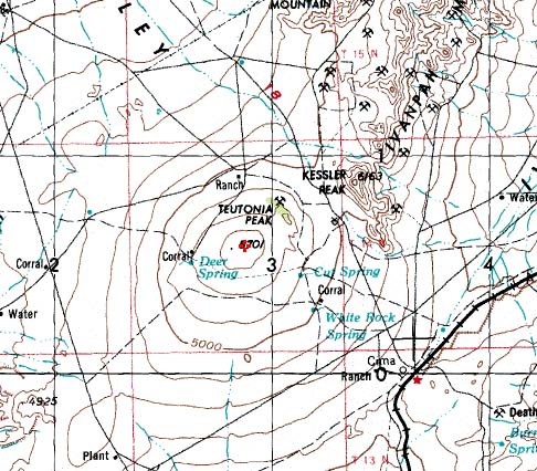
On a topo map you can easily make out the uniform concentric rings of the dome as it rises over 1500 feet from the lower points around it. In real life it’s a lot more subtle. You look at the ground as it rises, gradually, perfectly, and you get a torqued sensation that something is happening, but you’re not quite sure what. You stare and it looks like you see the curvature of the earth, though instead of flying high over it, you’re standing right on it. Space seems to distort as what you expect to be flat bulges up. Queasiness sets in. Welcome to Cima Dome.
The place has this amazing power and force that the touted 1960s and 1970s earthworks can’t begin to approach. In terms of spatial power, as interesting as they are, Robert Smithson’s Spiral Jetty, Michael Heizer’s various constructions, and James Turrell’s Roden Crater can’t hold a candle to it. Sorry guys!
So there I was, jeeping through the j-trees and the spatial queasiness, when I encounter a fence, a cattle guard, a power line and a powerline road crossing the jeep track. And next to the road, next to one of the power poles is a phone booth. A phone booth? A dozen miles from anything? A freaking phone booth? But out in the desert you see a lot of…unusual…things. And I stuck the phone booth as another entry in my brain’s cataloging of desert sights and sightings. Little did I know what I’d just seen.
[ go to part 2, i told you it was weird ]

